
THE UNKNOWN CALDERA
Everybody talks about her. Everybody takes photos of her. Everybody observes and admires her. However, how many people know that every single part of caldera hides its own history and name?
The caldera measures about 12 by 7 km (7.5 by 4.3 mi), with 300 m (980 ft) high steep cliffs on three sides.
There are two small volcanic islands at the center of the caldera, Nea ("New") Kameni and Palea ("Old") Kameni.
The caldera is composed of overlapping shield volcanoes, cut by at least four partially overlapping calderas, of which the oldest southern caldera was formed about 180,000 years before the present era (BP). The subsequent Skaros caldera was created about 70,000 years BP, and the Cape Riva caldera about 21,000 years BP. The current caldera was formed about 3600 years BP during the Minoan eruption.
Palea Kameni and Nea Kameni were formed as a result of multiple, initially submarine eruptions at the center of the caldera. Although dormant, Santorini is an active volcano. Numerous minor and medium-sized, mainly effusive eruptions have built the dark-colored lava shields of Nea and Palea Kameni inside the caldera.
Their last eruption was in 1950, and now only fumarolic activity, primarily inside the recently active craters, takes place. GPS instruments have registered renewed deformation around the caldera in 2011 and 2012.
The huge Minoan eruption of Santorini in the 17th century BC may have inspired the legend of Atlantis. It was rated 7, the highest score for a historical eruption, in the Smithsonian Global Volcanism Program's Volcanic Explosivity Index.
Location, log/Lat: 36.400510, 25.458821

Island of Santorini, Greece
Santorini is one of the best places on earth as far as sunset viewing is concerned. In fact few places can match the sheer beauty of Santorini’s sunset views. Visitor to the island fallen in love with bewitchingly beautiful sunsets that can be savored from many vantage positions in the island, such as Imerovigli.
Santorini is perhaps the most fascinating and most talked about island of Greece in the Aegean. Only the name of the island is enough to unfold in mind pleasurable connotations, volcanic landscape, gray and red beaches, dazzling white houses, terraces with panoramic sea views, stunning sunsets, wild fun. All this, together with remnants of lost civilizations discovered in the volcanic ash justify the epithets with which visitors identify Santorini and fairly is called, magical, indescribable, astonishing. The volcano is still active, and the last eruption was in 1950, causing an earthquake which destroyed many villages on the island. The island's official name is Thira and its main town, Fira, is also the capital of the Cyclades islands. Santorini became from the local “Santa Irini”.

OIA
Although a tourist spot, Oia remains an exceptionally artistic, hardly touched site; it is the part of the island least affected by tourism. A model of architecture, finesse and charm, Oia has its own fanatic followers: those who know how to appreciate what is different and unique!
What is Oia?
“Sea-wakened, proud / you lifted up your stone breast / speckled with the southwind’s inspiration / for pain to inscribe its very heart there. / For hope to inscribe its very heart there” (Trans. by Jeffrey Carson & Nikos Sarris). These were the words through which the great Greek poet Odysseas Elytis expressed his feelings for Oia in his poem “Ode to Santorini”.
The traditional village of Oia –a listed monument– unfolds along the volcanic rocks; it is the jewel of Santorini! Adored by everyone for its eternal exquisite beauty and unforgettable sunsets, Oia seduces visitors her picturesque yposkafa, i.e. residences carved into the rock, narrow paths and imposing Caldera.
History
In the Middle Ages (1335), Oia was one of the castellos, the fortresses, of the island erected by the Venetians; it was called “Aghios Nikolaos’ Castle” or “Panomerea” (the Upper side). The district was handed over to the nobility family of the Dargentas, who were Latinized Greeks. In order to be protected from pirate invasions, they built a tower with an observatory, called “Goulas”. This tower included all residences, the greatest of all belonging to the Castellan of Panomerea (Duke Dargenta). In 1579, the site passed to the Ottomans for 250 years; during this period it suffered numerous pirate raids. In 1650, an eruption of Koloumpo, an undersea volcano, destroyed the region. After 1850, its residents, the Panomerites, who were great sailors, returned to the activity they were renowned for: 165 sailing ships criss-crossed the Aegean, the Mediterranean and the Black Sea carrying famous Santorini wine. After the end of the Ottoman Occupation (i.e. after 1830), the regional economy flourished. It was then that Pano Meria (the Upper Side) changed its name to Oia; it had already become a small residential centre with 2.500 inhabitants. The architectural masterpieces being restored today date back to that glorious historical period.
Location Log/Lat: 36.462275, 25.385357

AKROTIRI
Nowhere in the world is there anything similar . Visiting Akrotiri is like travelling in time. Walk around the streets and squares of a pre-historic city of 30.000 inhabitants, admire the elegant mansions and high finesse of the 17th century B.C.
Akrotiri is a small fish village but the fact that such a remarkable civilisation flourished here for approximately fifteen centuries, gives it a special prestige. The ancient city of Akrotiri is the most important archaeological discovery in the Eastern Mediterranean. The volcanic eruption (1600 B.C.) covered with lava the ancient city and preserved it in an excellent condition, as happened in Pompeii. The fact that it covers such a large area (approximately 20 hectars), along with the excellent urban planning and the elaborate multi-storey buildings with the beautiful interior decoration (colorful wall paintings) designate the grandeur of this city. Visit the Kasteli of the Akrotiri and Goulato, which are really impressive! Also, admire the striking scenery of the white lighthouse on the rocks! Tip: Akrotiri is the point from which one can take the path leading to the Red Beach or the boat to the White Beach or the dirt roads leading to Mesa Pigadia, Almira and Gialos.
The Castelli of Akrotiri was built around 1335 and used to be called ‘Punta Castelli’ and ‘La Ponta’, which in Medieval Italian meant ‘the peak’. It was donated by Nikolas Sanudos, Duke of Naxos, to the Gozadini family, who kept the gulas under their power until 1617 even though the Turks had already invaded the rest of the island. There is also a second gulas at the Castelli of Akrotiri, a bit farther from the castle-city heart. Today the Akrotiri Castelli has revived, for a Museum and Workshop of Traditional Musical Instruments have been operating since 2012, while music nights from all over the world are being organized every Tuesday and Friday .
Tip:Walk up to the Castelli and Goulas in Akrotiri late in the evening, particularly when there are music nights.
Location Log/Lat: 36.351847, 25.403404

RED BEACH
The Red beach is the definition of a volcano beach. Everything here is red. The imposing rocks as well as the alteration of sand and pebbles. It’s a rather busy beach, island’s visitors seem to prevail. The Red Beach has been officially judged unsuitable for visiting due to unpredictable landslides in the area.
The red beach is arguably one of the most famous and beautiful beaches of Santorini. It is located only some steps away from the ancient site of Akrotiri. The small size of the beach creates a much crowded atmosphere and there are many days where most of the visitors choose not to make it all the way down to the beach and instead admire this unique landscape of red and black volcanic rocks from the headland.
Tip: You should be equipped with hats, suntan lotion and shoes for walking along the path. The temperature here seems to be twice as high as on the rest of the island. The two canteens at the parking are your last chance to find water and a snack.
How to get there: You can park in the road right below the archaeological site Rahidi and take the boat for the Red Beach, that runs every half an hour. Otherwise, when reaching the archaeological site, turn on the right, park in front of the chapel of Agios Nikolaos and continue on foot. In case you choose to go by car, you should be aware that there is a distance of about 5-10min that is quite rough. You can also take the bus to the beach.
Location Log/Lat: 36.348691, 25.394601

VISITING MUSEUMS
Visiting the Museum of Prehistoric Thera and the Archaeological Museum is as if plunging into the long and rich history of the island. The Museum of Prehistoric Thera hosts the important findings that were brought into light with the excavations in Akrotiri. Impressive plaster furniture mouldings, bronze pottery items and the unique golden statuette of the wild goat. The Archaeological Museum exhibits collections of sculptures and inscriptions from the Archaic to the Roman Era.
It would be better to visit Fira in the morning, when it is not that crowded. Have a glance at the Theotokopoulos Square, the meeting point overflowing with cafés and thousands of visitors! Gold Street with the jewellery stores and the commercial center Fabrika are poles of attraction, but you should also go ahead to Budi to enjoy the view of the caldera. The view is fantastic, as well as the happenings taking place at that spot. Now it is time for the Archaeological Museum of Thira , which includes collections of sculptures and inscriptions from the Archaic to the Roman Period, but also vessels from the Geometric until the Hellenistic Era. Visiting the incredible Museum of Pre-historic Thira you will get into the spirit of the civilisation developed at Akrotiri and admire the indelible colors of murals which remained intact under the lava. The Bellonias Foundation is the cultural center of the island, standing out with its colors, yellow ochre and cypress green , whereas the Gyzis Mansion has copper engravings from the 16th-19th century depicting local daily life scenes. The Santorini Orthodox Metropolitan Cathedral is situated in a unique position in the caldera and has wonderful religious paintings created by the Santorinian painter Christoforos Asimis when the church was rebuilt, following the earthquake of 1956. The Catholic Cathedral will impress you with its architecture and steeple. The Catholic women’s monastery, with twelve nuns, constitutes a remarkable monument. In the Folklore Museum, founded by Manolis Lignos in Kontohori of Fira , you will see a cave with the layers of lava deposits from the volcanic eruptions, as well as an authentic ‘kanava’ (see wine section).
Tip: From Fira one can take the cable car to go down to Gialos. Otherwise you can very well ride a ‘barron’ (donkey!) or walk down 587 steps!
Archaeological Site of Akrotiri, Akrotiri,T. +30 2286081939. Open daily, 8.00-20.00 (entrance fee 12€).
Archaeological Museum of Thera, Fira, T. +30 2286022217. Open daily, except Monday, 8.00-15.00 (entrance fee 2€).
Archaeological Site of Ancient Thera, Kamari. Open daily, except Monday, 8.00-15.00 (entrance fee 4€).
Museum of Prehistoric Thera, Fira, T. +30 2286023217. Open daily, except Τuesday, 8.00-15.00 (entrance fee 6€).
Location Log/Lat: 36.416608, 25.432610

FIRA:THE HEART OF SANTORINI
Fira became the capital of Santorini in the late 18th century. Before that, during the Venetian Occupation, the capital of the island had been Skaros, which used to be one of the island’s castles –the spot where today stands the cliff with the spectacular view over Imerovigli . When Skaros was gradually abandoned, the inhabitants settled to Fira which was then established as the new capital. First, Goulas (a medieval fort) was built on the top of the hill and the settlement developed around it. Besides the people from Skaros, it was also families from all over the island that moved to Fira. It is worth mentioning that until then, Fira had nothing else but kanavas (traditional wineries), vineyards and just a few summer dwellings. In 1956, an earthquake overwhelmed Fira. A great number of buildings were destroyed, among which the Orthodox Metropolitan Cathedral Panayia Bellonia (built in 1827). However, Fira was rebuilt from scratch always maintaining its urban structure, concentrating the central services and commercial traffic of the island, being a religious centrefor both Catholic and Orthodox residents.
Fira started being built in the 17th century, when the risk for pirate attacks had reduced. It was then that the old capital (the medieval Latin castle Skaros opposite Imerovigli) was abandoned. As for the architectural style of Fira, there are two main types of dwellings: ‘yposkafa’ (cave houses, for the lower class) and urban houses (for the upper class). Υposkafa were domed caves dug into the volcanic tuff sand that covers the upper soil layer of the island; they comprised two consecutive spaces: one living room and one bedroom. There was also a small kitchen with a baking oven in the yard. As for urban dwellings, these were initially built in a plain form; however, in the 19th century, they took the form of mansions as a result of the prosperity brought forward by the flourishing of commerce and maritime in the 19th century. The architectural style was initially influenced by the Venetian architecture, but later on (late 19th-early 20th century) neoclassical morphological elements were also integrated. Churches also present high architectural interest: basilicas and cruciform-domed, with characteristic domes and square steeples. Remarkable indeed was the skill and passion of Santorinian craftsmen who attributed exceptional details to mansions and churches impressing all of us until today.
The primary materials for the construction of houses and churches came straight from the island’s volcanic soil, such as volcanic black and red rocks, pumice, volcanic ash mixed with lime, while the wood was imported mainly from the islands of Ios and Crete. As there was lack of wood in Santorini, the most characteristic architectural element of both mansions and hyposkafa were vaulted roofs. Floors were mainly made of mortar, while yards and alleys were coated with volcanic rocks.
Every visitor today should discover some of the most characteristic samples of Santorinian architecture that are mentioned below. It is worth visiting Frangomahalas in Ano Fira and the suburb of Agios Minas in Kato Fira. In Frangomahalas, you will be impressed by the restored castle-house Goulas, Megaro Gyzi (family mansion of 17th century), Vazegios mansion with Venetian architectural style, as well as the Catholic Diocese complex comprising the churches of St John the Baptist (mid-17th century) and the Rosaria Dominican Convent (1825). Classical architectural sample is also the small church of Agios Stylianos clinging to the edge of the caldera, as well as the church of Agios Minas and Christ’s church in Kato Fira. The district below the Orthodox Metropolitan Cathedral has the most awesome view. Remarkable is also the Atlantis Hotel, which was built in 1955 and survived the earthquake. Do not miss Sarpaki Square at the southern end of Fira. Samples of modern architecture are the buildings of the National Bank and the Archaeological Museum with a beautiful indoor patio and palm trees on the renovated square right in front.
Fira lies along the caldera in the centre of the island, starting from the area called Balades (where stands the abandoned mine-building) and spreading up to the Monastery of Agios Nikolaos in Firostefani. Kontohorio is the eastern district, while the harbor of Fira is located in Mesa Gialos, on the foot of the hill from the caldera side. That is where cruise visitors get off and go up to Fira in cable car, on foot (up the stairs) or on donkey back. About two kilometers out of the centre of Fira, there is Exo Gialos, a quiet beach with a picturesque cove, few hotels and one tavern.
According to Emmanuel A. Lignos, Fira is divided into the following main districts: Centre, Kato Fira (below the Orthodox Metropolitan Cathedral), Frangomahalas (Catholic district, northeast), Kontohori (east) and Firostefani (north), the last one considered to be the natural expansion of Fira.
Fira today is the liveliest place on the island: breathtaking view, exquisite shops, delightful restaurants and exciting night life! Do not miss discovering the heart of Santorini. Picturesque alleys, extravagant mansions, impressive hyposkafa on the foot of the caldera, numerous corners with spectacular view, rich history and enchanting beauty. Fira has been writing its own history upon the rocks of the most astonishing caldera in the world.
Location Log/Lat: 36.420517, 25.431495

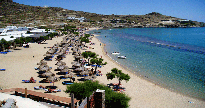
MONOLITHOS BEACH
Monolithos is on the south east coastline of Santorini.
A beautiful golden sandy beach with crystal clear waters next to Kamari at a distance of about 9 km from Fira. In Monolithos area is located the Santorini airport. Monolithos is a quiet beach but well organized, with all the comforts (even sea sports). Hotels, beach bar, umbrellas and taverns are available.The area is surrounded by various hotels and rooms, restaurants and cafes. There is a football pitch, basketball court and for children a nice play area. There are also trees at the back of the beach for shade seekers.
This beach reveals a pleasant atmosphere, that is why it is often crowded with children.
The village was named (monolithos in Greek stands for one rock) after the solitary rocky outcrop and the soaring smokestack of the tomato paste plant. With its broad beach of fine black sand and seemingly endless shallows, Monolithos has inevitably developed into a family resort.
Location Log/Lat: 36.412164, 25.483272

 |  |  |  |  |  |  |
|---|---|---|---|---|---|---|
 |  |  |  |  |  |
AMMOUDI : THE SECRET DIAMOND
You can reach Ammoudi either by following the coastline road behind Oia or going down the 214 stairs connecting it to Oia. This bay used to teem with life, for it was the transit trade port. Ammoudi, along with Armeni (on the front side of Oia), used to be the ports of Oia in the 19th and 20th centuries.
Among the most favourite moments on the island: walking along the dust road to reach the small beach with the cliffs, diving into the deep waters and swimming below the caldera, above the sea bottom chaos (here there are no sunbathing comforts etc). Then going to the taverna with the yellowish colours on the walls for fish and sea dishes and waiting for the sunset. The sun vanishes behind Thirasia and from this spot you have the sunset with the longest duration!
Location Log/Lat: 36.464113, 25.368851
